|
An enormous extratropical low is creating havoc along the entire
Eastern Atlantic Seaboard in this infrared image at 1200 UTC (0700 EST) on
October 30, 1991. Labelled the "perfect storm" by the National Weather
Service, the storm sank the swordfishing boat Andrea Gail, whose story
became the basis for the currently best-selling novel "The Perfect Storm"
by Sebastian Junger. A little-known and bizarre ending came to this
monster, which came to be known as the Halloween Storm. To tell this
incredible story in its entirety, the Satellite's Eye Art Gallery spans
two subject headings (Extratropical Cyclones and Hurricanes)!
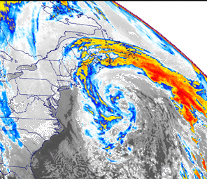
The color-enhanced infrared image of 1200 UTC October 30, 1991
depicts a monster storm off the Eastern Seaboard, which was described by
the National Weather Service as the "perfect storm." In this image, the
storm was at its peak intensity. The storm became subtropical thirty
hours later, just before the inner core of the storm developed into a
topical storm and later an unnamed hurricane.
History of the StormLate October and November are months with weather in rapid transition in the eastern U.S. To the west, large fresh cold air masses from Canada begin to envelope the Midwest on a regular basis. To the east, the Atlantic Ocean is slower to lose its stored summer heat than the continent, and hurricanes sometimes form over the warm waters. The contrast between two very dissimilar air masses often results in massive storms just offshore of North America. These tempests, called "Nor'easters" in the Atlantic states, have sunk many ocean vessels, and this storm lived up to the reputation of being severe. On October 28, 1991, a extratropical cyclone developed along a cold
front which had moved off the Northeast coast of the U.S. By 1800 UTC,
this low was located a few hundred miles east of the coast of Nova
Scotia. With strong upper air support, the low rapidly deepened and
became the dominant weather feature in the Western Atlantic. Hurricane
Grace, which had formed on October 27 from a pre-existing subtropical
storm and was initially moving northwestward, made a hairpin turn to the
east in response to the strong, westerly deep-layer mean flow on the
southern flank of the developing extratropical low. Grace was a large
system and it was already generating large swells ranging in size from
about 15 feet offshore of North Carolina to about 10 feet near the
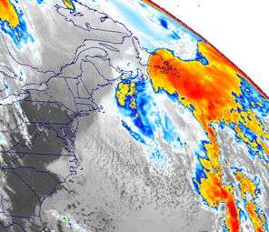
Florida coastline. As the low pressure continued to deepen on October 29, Grace became
only a secondary contributor to the phenomenal sea conditions which
developed over the Western Atlantic during the next few days. At 1800
UTC on the 29th, the vigorous cold front from the extratropical low
undercut and quickly destroyed Grace's low level circulation east of
Bermuda (Note the red and yellow area east of Charleston, SC in Figure
1). The remnant mid- and upper-level moisture from Grace became caught
up in the outer part of the extratropical storm center's circulation,
far from the storm's center. By the next day these remnants had become
indistinguishable. The center of the extratropical low drifted
southeastward and then southwestward, deepening all the time. It reached
peak intensity of 972 mb and maximum sustained winds of 60 knots at 1200
UTC on October 30, when it was located about 340 n mi south of Halifax,
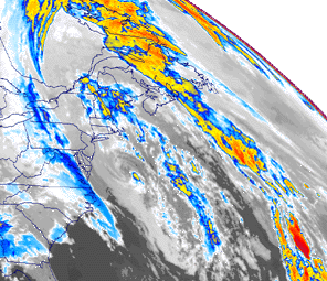
Nova Scotia (See Event Discussion image above). After reaching peak
intensity on October 30, the low retrograded southwestward on October 31
(Note swirl off Delmarva Peninsula in Figure 2), and then southward as
the central pressure rose to about 998 mb by 0000 UTC on November 1.
65 Knot Winds/ 39 Foot Wave Heights During the early phase of the storm's history, a strong high pressure
center extended from the Gulf of Mexico northeastward along the
Appalachians into Greenland. Strong winds were generated from the tight
pressure gradient between a strong high pressure center in eastern
Canada (1043 mb) and the surface low. Phenomenal seas and strong winds
and waves along the eastern U.S. coastline occurred at this time.
Several vessels passed close to the extratropical storm center on
October 30 and reported winds of 50-60 knots. NOAA buoy 44011 located at
41.1 degrees N, 66.6 degrees W reported maximum sustained winds of 49 kt
with gusts to 65 kt and a significant wave height of 39 feet near 1500
UTC. Buoy 44008 located at 40.5 degrees N, 69.5 degrees W reported
maximum sustained winds of 53 kt with gusts to 63kt and a significant
wave height of 31 feet near 0000 UTC on October 31. Other
unsubstantiated observations reported winds and waves considerably
higher. North Carolina's coast was lashed with occasional winds of 35 to 45
mph for five consecutive days. In New England on October 30-31, wind
gusts of above hurricane force pounded the Massachusetts coastline.
Representative peak gusts included: 78 mph at Chatham NWS, 74 mph at
Thatcher Island, 68 mph at Marblehead, 64 mph at Blue Hill Observatory
(all in Massachusetts) and 63 mph at Newport, RI. Even more damaging
were the heavy surf and coastal flooding caused by the tremendous seas
and high tides caused by the long overwater fetch length and duration of
the storm. Waves 10 to 30 feet high were common from North Carolina to
Nova Scotia. High tides pushed to from three to seven feet above normal.
In New Jersey, the greatest tidal departures of winter storms of record
occurred during this event, with tide heights exceeded only by the Great
Atlantic Hurricane of 1944. In Delaware, Maryland, and Virginia, the
highest water levels were comparable to those of the nor'easter of
March, 1962. A record high tide of 7.8 feet occurred at Ocean City, MD
on the 30th, which eclipsed the old record of 7.5 feet recorded during
the March 1962 storm. In Massachusetts, 25-foot waves reached the
shoreline atop high tides already 4 feet above normal. At Boston, the
tide reached 14.1 feet above mean low water or about 1 foot less than
the tides associated with the "Blizzard of 1978." Elsewhere treacherous
swells, surf, and associated coastal flooding occurred along portions of
the Atlantic shoreline extending from Puerto Rico and the Dominican
Republic, to the Bahamas, along the U.S. and Canada and in Bermuda.
Search and Rescue Satellite-Aided Tracking System (SARSAT)
According to "The Perfect Storm" book, The Andrea Gail is presumed to
have sunk sometime after midnight on October 28 when the storm was still
intensifying. The vessel was equipped with a 406 MHz EPIRB (Emergency
Position-Indicating Radio Beacon) which is used to notify search and
rescue authorities of a distress situation. However, the EPIRB was found
with the switch turned off. Such is not the case with many vessels where
activation of the 406-Megahertz EPIRB has been detected by NOAA's
weather observing satellites, and has led to swift rescue when they have
been in trouble. The Search and
Rescue Satellite-Aided Tracking system (SARSAT), was developed in a
joint effort by the United States, Canada, and France. In the United
States, the system was developed by NASA and its operation was turned
over to NOAA where it remains today. Today there are more than 63,000
EPIRBS in the NOAA 406 MHz Registration Database. These EPRIBS, which
are reserved for use in maritime operations, and similar Emergency
Locator Transmitters (ELTs), used for the location of downed aircraft,
have dramatically reduced the time to reach accident victims. In an odd
twist of fate, the 406-Megahertz EPIRB identified as belonging to The
Andrea Gail was found washed ashore on Sable Island on November 5.
Widespread Extensive Damage A state
by state damage summary reveals the widespread and extensive damage
caused by the storm and accompanying seas. Beach erosion and coastal
flooding was severe and widespread, even causing damage to lighthouses.
Hundreds of homes and businesses were either knocked from their
foundations or simply disappeared. Sea walls, boardwalks, bulkheads, and
piers were reduced to rubble over a wide area. Numerous small boats were
sunk at their berths and thousands of lobster traps were destroyed.
Flooding was extensive invading homes and closing roads and airports.
Former President Bush's home in Kennebunkport, ME suffered damage as
windows were blown out, water flooded the building, and some structural
damage also occurred. Even inland areas suffered major damage. The
Hudson, Hackensack, and Passaic Rivers all experienced tidal flooding,
and high winds brought down utility poles, lines, tree limbs, and signs
in several states. The most extensive damage occurred in New England where federal
disaster areas were declared for seven counties in Massachusetts, five
in Maine, and one in New Hampshire. Off Staten Island, two men were
drowned when their boat capsized. Other fatalities occurred when a man
fishing from a bridge was either blown or swept off in New York and a
fisherman was swept off the rocks at Narrangansett, RI by heavy surf.
Offshore, six lives were lost when the Andrea Gail, a swordfishing boat,
sank. Total damage in the Halloween Storm, as it came to be known
because of its date, was in the hundreds of millions of dollars.
Bizarre End to the Halloween Storm
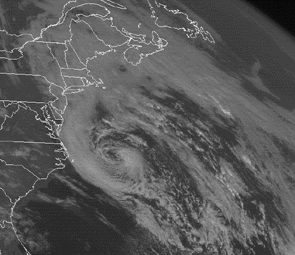
The southward motion of the cyclone on October 31 had brought the
storm over a section of the Gulfstream with sea surface temperatures
near 26 degrees C (80 degrees F). Convection began increasing in bands
near the center and it is estimated that subtropical characteristics
were acquired at 1800 UTC on October 31, setting the stage for a bizarre
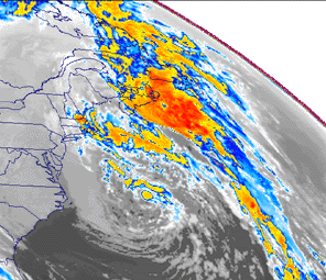
ending to this storm (See Figure 3). By 0600 UT on November 1, central convection had increased to the
point where a tropical cyclone (estimated to be of tropical storm
intensity) could be identified within the central area of the low (See
Figure 4). Later it became a true hurricane in every sense of the word.
Images of the hurricane phase and a discussion as to why this storm will
be remembered in history as the "Unnamed
Hurricane" can be found in the Hurricane
Gallery of the Satellite's Eye Art Gallery.
| |||||||||||||||||||||||||||||||||||||||


